Airport environment
- Runway markings
- Runway numbers
- Magnetic heading
- Last digit excluded
- Rounded to nearest 10º
- Based on most common wind condition
- Threshold line
- Where the runway starts
- Threshold marker
- Number of parallel lines that represent runway width (AIM 2-3-3)
- Displaced threshold
- Takeoffs and taxi is ok, NO LANDINGS
- Touchdown zone marker
- 500 feet from the threshold line
- 1,2 or 3 parallel lines
- Aiming zone marker
- Two white rectangular stripes 1000 feet from the threshold
- Blast Pad/over run area
- Used for jet wash
- No takeoff,taxi,or landing
- Emergency use only
- Taxiway markings
- Holdshort line
- Not allowed to cross solid lines without clearance
- Cross dashed line after landing, then stop if not instructed otherwise
- ILS holdshort
- Prevents interference with ILS signal
- Non-movement area line
- Marks the border between movement area and non movement area
- Movement area is the part of the airport where aircrafts takeoff/land
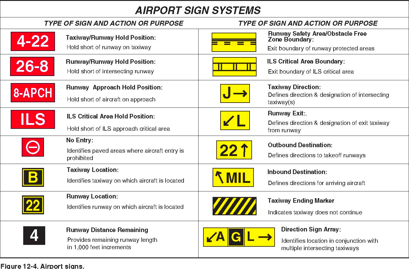
- Airport signs
- Mandatory instruction signs
- Red background with white letters
- Runway entrance
- Critical area
- Area prohibited for aircrafts
- Locations signs
- Black background with yellow text
- Identifies your location
- Direction signs
- Yellow background with black text
- Always contains arrows
- Direction to taxiway or runway
- Destination signs
- Yellow background with black text
- Always contains arrows
- Directions to location
- Terminal, cargo, fuel, parking
- Runway distance signs
- Black background with white numbers
- Posted along the runway
- Remaining runway distance in thousands of feet
- Runway incursion avoidance
- When an aircraft, vehicle, person, or equipment is on the runway without clearance
- No part of the aircraft can cross the solid line of the holdshort line
- Do not enter or cross the runway unless cleared
- If in unfamiliar airport
- Hard to see where you are going
- Ask for progressive taxi
- Land and holdshort operations - LAHSO
- The PIC has to determine if this is possible or not
- PIC is expected to decline his operation if it will compromise safety
- If you accept a LAHSO you should land and exit the runway at the first convenient taxiway
- If go around necessary, maintain separation and notify ATC
- Approach lighting system
- See TPP’s for different types
- Dot means running rabbit
- Black means pilot controlled lighting
- See regulations 91.175 takeoff and landings under IFR
- Red terminating bars
- Runway lighting
- Threshold lights
- Bidirectional
- Green at beginning of runway, Red at end of runway
- Runway edge lights
- High, medium, low intensity lights → HIRL, MIRL, LIRL
- You can usually change intensity by pilot controlled lighting
- Runway centerline lights
- Only instrument precision approaches
- White in the beginning, alternating white/red last 3000 feet, red last 1000 feet
- Runway end identifier lights - REIL
- Provides rapid and positive identification of the approach end
- Airport beacon and obstruction lights
- Operational from dusk til dawn and during IFR
- Civil airport → white/green
- Military airport → white white green
- Heliport → white green yellow
- Seaplane → white yellow

Airspace
- Controlled airspace
- You need a clearance and file a flightplan
- You fly the altitude which ATC assigns you
- If cleared for vfr-on-top follow vfr cruising altitude
- Uncontrolled airspace
- Might be a lot of non transponder vfr traffic
- No separation
- You don't need clearance or file a flightplan
- You fly altitudes that are appropriate to 91.179
- Aircraft speed limits - FAR 91,117
- Below 10,000ft: 250 kias (includ. class B)
- Class C, class D, within 4 nm of the primary airport at or below 2,500 agl: 200 kias
- Airspace underlying class B: 200 kias
- Special use airspaces - MC WRAPN
- Military area
- IFR traffic may not go through unless cleared by ATC
- If not cleared, ATC will reroute nonparticipating IFR traffic
- Controlled firing area
- Activities are suspended immediately when an aircraft is in the area
- Not on the chart
- Warning area
- 3 nm outward from the coast of the US
- Contains activities that may be hazardous to nonparticipating aircrafts
- Restricted area
- If “cold”, ATC will allow IFR traffic without clearance
- If “hot”, ATC will issue clearances which assures the aircraft avoids the area
- Alert area
- High volume of aircrafts
- Be alert
- Prohibited area
- Flight for aircraft is prohibited
- NSA area
- Locations where increased security for ground facilities is required
- Pilots are requested to avoid the area
- NSA can make area prohibited
- Other airspaces
- Military training routes
- IFR/VFR (IR/VR)
- MTR’s with no segment above 1500 agl will be identified by 4 numbers
- MTR’s with one or more segments above 1500 agl will have 3 numbers
- Temporary flight restrictions (TFR’s) - FAR 91.137
- TFRs are established to protect persons and property in the air or on the surface, aircrafts are prohibited to fly through
- A NOTAM will be issued designating an area within which TFR’s apply and specify the hazard of conditions requiring their imposition
- Aeronautical Information Manual (AIM)
- Basic flight info and ATC procedures
- Chart directory
- Shows airport information including
- Terminal Procedures Publication
- Airport sketches
- Runway info
- NAVAIDs
- Communications data
- Weather data sources
- Airspace, special notices
- VFR waypoints
- Airport Diagrams and operational procedures
- Electronic flight publications
- Government printing office
- Responsible for printing and distributing information products and services for the executive branch, Congress, and the federal judiciary
- Notices to Airmen (NOTAMs)
- General
- Information that could affect the pilots go/no-go decision
- Contains info like
- Runway closure
- Hazardous activity
- Obstacles
- Nav aid status
- Landing operations
- Valid for 28 days unless canceled earlier
- Four types
- Notam (D)
- Notam (FDC)
- Notam (Pointer)
- Notam (SAA)
- Notam (military)
- Flight Data Center
- Part of the FAA's Aeronautical Information Services group
- International Flight Information Manual
- Publishes as a preflight and planning guide for use by U.S. nonscheduled operators, business, and private aviators flying outside of the United States
- Updated annually
- Advisory Circulars (ACs)
- General
- Issued by the faa as a systematic way to deliver non regulatory material of interest such as wake turbulence
- Also endorsements
- Numbering system
- 20 - aircraft
- 60 - airmen
- 70 - airspace
- 90 - air traffic
No comments:
Post a Comment