VOR navigation
- How they work
- Very high frequency omnidirectional range
- Sends out two different signals. One master and one secondary
- Master signal is constant for each radial
- Secondary signal rotated about the station
- Receiver compares the two signals and can tell you where the selected radial is
- Limited to line of sight
- Station and radials
- 360º
- Radials are always from the station
- Oriented to magnetic north
- VOR roughness
- Minor CDI roughness brief flag alarm if flying over mountainous terrain
- Standard service volumes

- HSI
- Combines vor and directional gyro
- Also gives you glide slope
- VOR navigation
- Station ID
- Find the morse code on sectional or low enroute chart
- Press ID button -> turn up volume -> listen to morse code
- During maintenance morse code removed or send out test signal ( _••••_ )
- Intercepting radial
- Take the difference between the radial you are on and the radial you want to intercept
- On radial 100 and want to intercept radial 120 -> 20º difference
- Radial difference * 2 ( not less than 20º and not more than 90º intercept angle)
- If flying to the station, always set course to reciprocal radial
- Turn into the course
- Tracking
- Follow the selected radial
- If the CDI goes to the left, turn to the left
- Remember to correct for wind drift
- Homing
- Continuously twist the obs knob to center the CDI
- Reverse sensing
- When the CDI indicates the reverse of normal operations
- This will happen to a basic VOR if you set it to the reciprocal of the intended course
- Station passage
- The CDI will be more sensitive the closer you get to the station
- Eventually oscillations and/ or full scale deflection
- Cone of confusion
- Nav flag may also appear
- Station passage is complete with flag flip (to/from)
- 1 NM from VOR maintain heading
- Has to be done every 30 days
- VOR - VOR test facility
- Transmits a test signal which can be found in the A/fd
- Procedure
- Tune in frequency in vor receiver (A/FD)
- Center the CDI needle
- Should read 180º with a TO indications or 0º with FROM (think blink 182
- Maximum error is +/- 4º
- VOR receiver checkpoint
- Frequency and radial can be found in A/fd
- Procedure
- Tune in frequency in VOR receiver
- Center CDI needle
- Should read radial specified in A/fd with a from indication
- Max error +/- 4º for ground check
- Maximum error +/- 6º for airborne check
- Dual VOR check
- Used for 2 VOR independent from each other
- Maximum error is 4º between 2 receivers
- VOR records
- Each person making the check must enter the info in the aircraft or other records(91.171)
- “D.P.E.S” date, place, error, signature
- VOR, VOR DME, AND VORTAC
- VOR provides course information
- VOR.DME provides course and distance
- VORTAC is both VOR and tacan
- TACAN is used by military - provides course and distance

DME navigation
- Distance measuring equipment
- Works on line of site
- Aircraft has a DME transmitter that send out radio frequency pulses
- A ground facility receives the signals and sends them back to the aircraft
- The airborne DME measures time between the signal and translates it into distance
- Reliable signal will be received up to 199 NM line of site
- Slant range
- Distance is measured from your aircraft to the station, not ground distance
- The error is greater the higher you are and the closer you are to the station
- DME arc

- Usually a transition to the approach course
- How to fly it
- Lead the turn into the ark by 0.5 NM
- Turn 90
- Monitor your distance
- Turn 10º twist 10º → continuously center the CDI needle
- Frequency pairing plan
- You only have to put in the VOR frequency to receive the distance info
- This assumes that the station has DME info (VOR/DME, VORTAC, ILS/DME,LOC/DME)
- DME is identified by a morse code with a tone slightly higher than the VOR/LOC tone
- Heard once every 3 - 4 times the VOR/LOC
NDB navigation
- Ground facility
- Called NDB - non directional radio beacon
- Transmits radio energy in all directions
- Frequencies
- Not approved for IFR navigation but can be used for VFR
- ADF receivers do not have a "flag" to warn the pilot when erroneous bearing information is being displayed
- The pilot should continuously monitor the NDB's identification
- ADF - automatic direction finder

- Equipment in the aircraft
- Always points to the antenna
- Shows you the relative bearing from the aircraft's magnetic heading to the transmitting station
- RMI - radio magnetic indicator
- ADF’s version of the HSI
- Combines and ADF with a heading indicator connected to a fluxgate
- MH + RB = MB


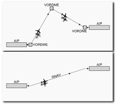
Area Navigation (RNAV)
- Basic of area navigation
- Enables point to point navigation without the need of overflying a station
- Airborne computer determines the aircraft position, actual track, and groundspeed
- Rnav equipment include VOR/DME with airborne computer or GPS
- RNAV equipment must be approved for use under IFR
- VOR/DME RNAV
- Creates a waypoint by using an airborne computer
- Uses facility to make angles to calculate distances

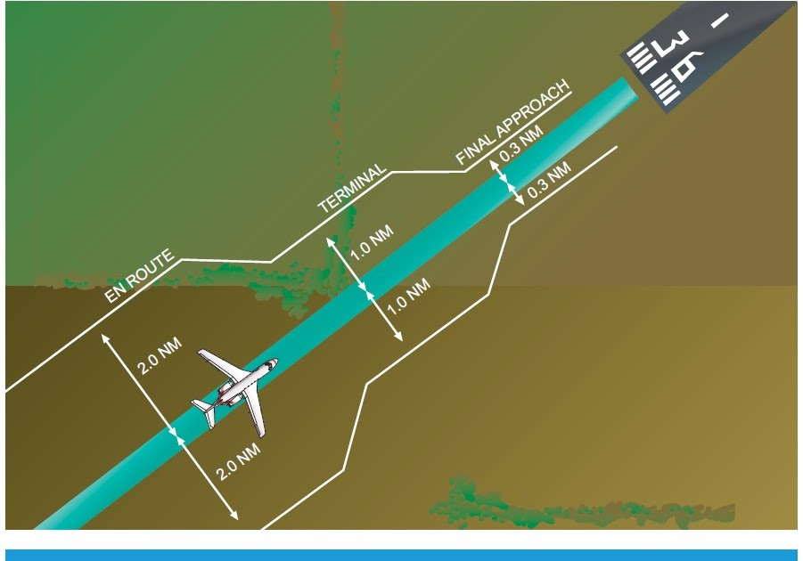
RNP - Required navigation performance
- Type of Performance-based Navigation that allows an aircraft to fly a specific path between two, 3 dimensionally defined points in space
- RNP is very similar to RNAV
- Only difference is on-board performance monitoring and alerting
- Ensure that the aircraft stays within a specific containment area
- Must stay in defined space for 95% of the time
- Levels of RNP
- Distance from the centerline of the flight path that must be maintained (95%)
- Enroute - 2.0 nm
- Terminal - 1.0 nm
- Approach - 0.3 nm
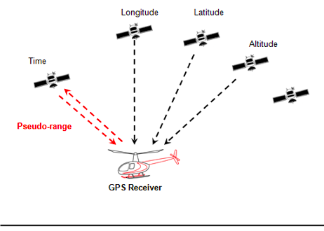
GPS - global positioning system
- Developed and operated by the DoD
- 31 satellites
- 5 should be in view at all times
- 6 orbital planes, 4 in each
- 3 distinct functions
- SPACE: all the satellites
- CONTROL: ground based GPS monitoring and control station to ensure accuracy
- USER: receiver that calculates position, speed and distance
- How it works
- Satellite transmits a specific code
- Contains info about position, time, health, accuracy, etc
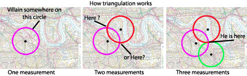
- Receiver calculates the time it took for the signal
- At least 4 satellites for 3D position
- 4th used for accuracy since the satellites use atomic clocks, and receivers don't
- RAIM - receiver autonomous integrity monitoring
- Integrity is often defined as the ability of the navigation system to provide timely warnings to the user when it is inadvisable to use the system for navigation
- Detects if the GPS is not accurate enough
- Senses if the satellite is providing corrupt info
- Needs at least 5 satellites in view for fault detection
- RAIM fault detection algorithm
- Fifth satellite is the one to monitor the other four
- Needs 6 satellites in view for fault exclusion
- RAIM exclusion algorithm
- If RAIM is lost
- We have a notification of ‘Loss of Integrity’ symbol that appears on our PFD
- On an approach, we must execute a missed approach immediately
- Passed our FAF, time period of up to 5 min to land before executing a MAP
- WAAS - wide area augmentation monitoring
- System of satellites and ground stations that provide GPS signal corrections, giving better accuracy
- How it works
- Multiple ground reference stations positioned across the U.S. that monitor GPS satellite data
- 2 master stations, located on either coast, collect data from the reference stations and create a GPS correction message
- Correction accounts for GPS satellite orbit and clock drift plus signal delays caused by the atmosphere and ionosphere
- Corrected differential message is then broadcast through 1 of 2 geostationary satellites
- The information is compatible with the basic GPS signal structure, which means any WAAS-enabled GPS receiver can read the signal
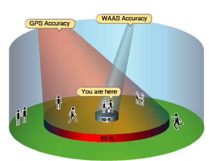
- WAAS accuracy → 10 feet/ GPS accuracy → 50 feet
- Allows you to fly gps approaches with vertical guidance
- Also uses Fault Detection and Exclusion
- Regulatory requirements for ifr GPS navigation
- Receiver must be IFR approved
- Preflight: check GPS NOTAMS
- Database must be up to date (every 28 days)
- Aircraft must be equipped with an approved and operational alternate means of navigation (VOR)
- If RAIM, alternate navigation must be monitored only when RAIM is lost
- If no RAIM
- Alternate navigation must be actively monitored
- Alternate airport must have other than GPS approach
- WAAS receivers can be primary throughout the flight
Radar
- Primary radar function
- Displays aircraft by reflection
- Reflection includes only range and bearing to the radar
- Radar limitations
- Radio waves can be bent/interfered by
- Ground obstacles
- Heavy clouds
- The smaller the aircraft, the smaller the return signal
- Transponder
- Used with secondary radar to improve coverage and include altitude
- Need mode c to report altitude
- How they work and how to use them
- ATC radar sends signal → transponder receives signal and sends coded reply
- Regulatory considerations
- If transponder installed, it must be on at all times in controlled airspace
- Altitude reporting must be on in A,B,C airspaces
- Within 30 nm of bravo up to 10000 feet msl
- Above B and C up to 10000 feet msl
- Above 10000 feet msl except below 2500 agl
- ADS-B - Automatic dependent surveillance broadcast
- AC broadcasts a message on a regular basis
- Includes position, speed, and other info
- Reports based on satellite navigation system
- The broadcast report is called ADS-B out
- Basic about ADS-B
- Other aircraft systems can receive the report/info if they have ADS-B IN
- Can be used to obtain NOTAMS, weather, etc
- 91,225
- January 1st 2020 ADS-B out will be a required for all aircraft's in the same airspace's where transponders are needed
.
No comments:
Post a Comment