Weather and observation network
The forecasting process
- Forecasting methods
- Persistence forecast
- Predicting that the weather you are experiencing will continue
- Trend forecast
- The assumption that the weather systems that are moving in one direction and speed will continue
- Climatological forecast
- Basing the outlook on the average weather in the region
- Analogue forecast
- Combining historical info with other prevailing weather elements
- Compares the current weather chart with those of a similar chart from the past
- Meteorological forecast
- Generally more accurate → uses forecaster’s scientific knowledge of atmospheric process to generate weather predictions
- Numerical weather prediction
- Increased forecast accuracy can be accomplished using powerful computers and complex software
- Compiling and processing weather data
- Predicting weather conditions begins with an analysis of present and past conditions
- Weather info is passed among various agencies for processing and analysis, and creation of charts, graphic, and texts
- Forecasting accuracy and limitations
- Due to large distances between weather reporting stations and the length of time between weather reports.
- Atmosphere occasionally does not behave exactly like computers think it should
- Weather analysis
- Different ways to receive weather
- Calling the briefer
- DUATS (direct user access terminal system) via personal computer
- www.aviationweather.gov
- In-flight weather sources
- Weather stations can be automated or manned
- Depending on station type, it can give you more or less info
- Different types of station
- ASOS - automated surface observing system
- AWOS - automated weather observing system
- AWSS - automated weather sensor system
- ATIS - automated terminal info service
- Three types of weather information products
- Depicted - current weather
- Forecast - future weather
- Warning - dangerous weather
- Depiction product
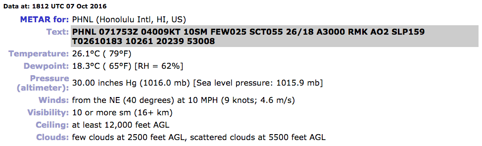
- METAR - aviation routine wx report (METeorological Aerodrome Report)
- PIREPs
- SD - radar summary chart
- Satellite
- Wx depiction chart
- Surface analysis chart
- Constant pressure chart
- Composite moisture stability chart
- Metar
- Issued hourly
- Contains local conditions
- Updated when significant change occurs (SPECI)
- Used to determine flying conditions (VFR, MVFR, IFR)
- PIREP - pilot report
- Reported to FSS
- Wind direction is magnetic
- Two types
- UA - routine report
- UUA - urgent report (big difference between current wx and reported/forecast wx)
- Radar summary chart
- Computer generated
- Issued every 30 min
- Shows precipitation detectable by radar:
- Clouds coverage
- Cell movement
- Echo top
- Possible precipitation
- Satellite
- Takes pictures
- Generally observes
- Clouds
- Climates
- Can also observe
- Sand and dust storms
- Volcanic ash
- Fire/smoke
- Surface analysis chart
- Computer generated
- Issued every 3 hours
- Weather information
- Frontal analysis
- Pressure patterns
- High and low pressure areas
- Winds
- Temperature / dewpoint
- Weather forecast
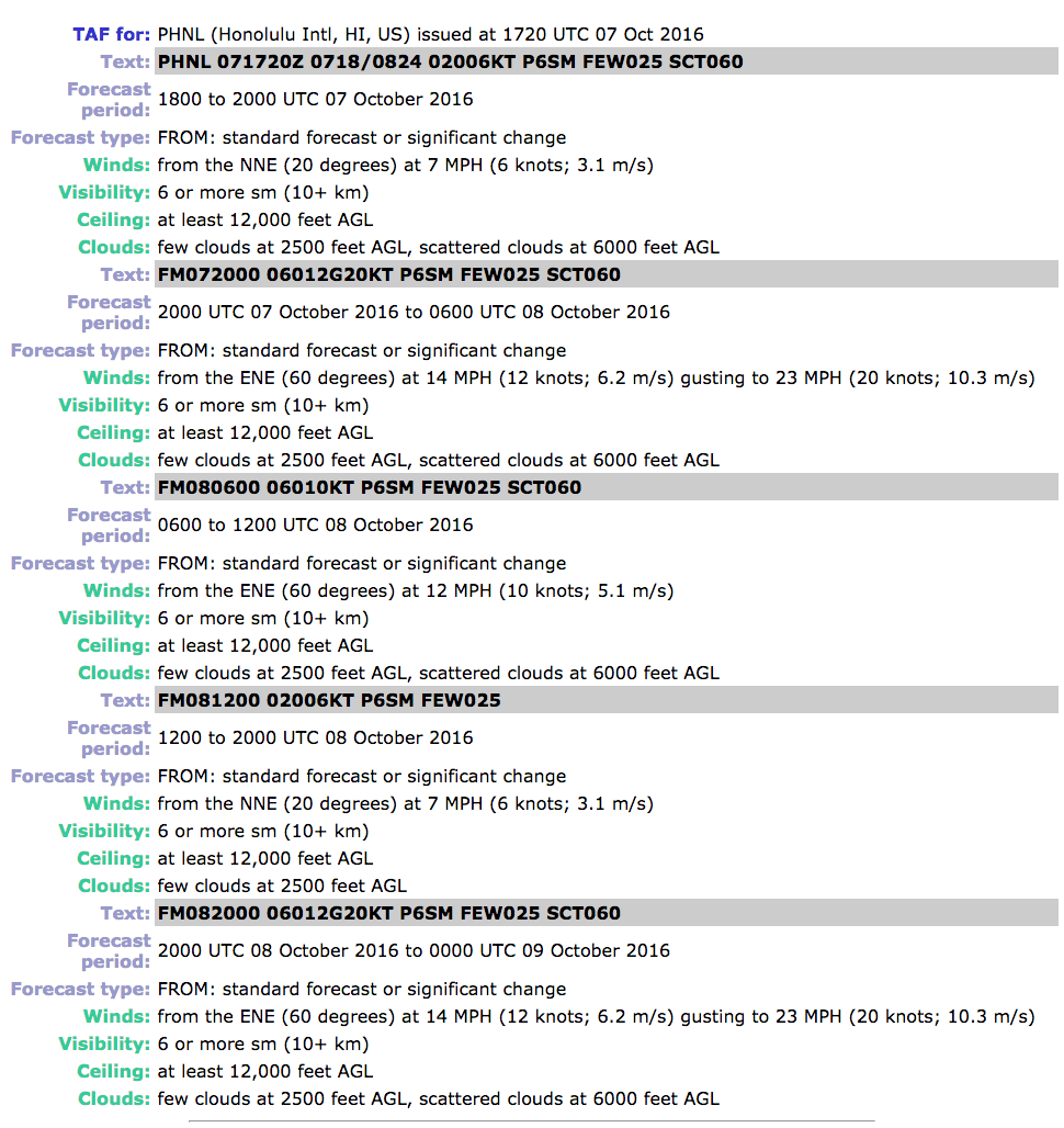
- TAF - terminal area forecast - 4 hours
- FA - area forecast - 8 hours (USA has 6 FA)
- FD - wind and temp. aloft forecast - 12 hours
- Route forecast
- Significant wx prognostic chart
- TWEB - transcribed wx broadcast
- Terminal area forecast (TAF)
- Prediction of surface weather expected at an airport:
- Issued 4 times a day
- Valid 24 hr
- Weather on 5 sm radius from the airport


- Wind and temp aloft forecast
- Forecasts 9 levels between 3000 ft – FL390.
- Winds aloft are not issued within altitudes 1500 of location’s elevation
- Issued twice a day
- Wind direction is true
- Temperature is in Celsius
- 9900 – wind calm
- Wind more than 100 knts
- Subtract 50 from direction
- Plus 100 to the speed
- A forecast of 250 degrees, 145 Kt, is decoded as 7545
- Wind more than 200 knts
- Subtract 50 from direction
- Wind speed is 199 or more
- 270 degrees at 199 Kt or greater, is decoded as 7799
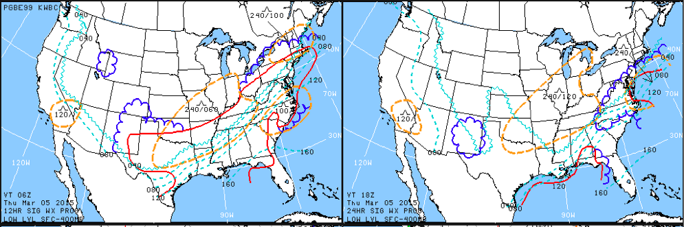
- Significant weather prognostic chart
- Provides 12-24 hour forecasts:
- High and low pressure systems
- Frontal analysis
- Precipitations
- Ceilings
- Turbulence
- Freezing levels
- Thunderstorms
- Jet streams
- Divided in a chart of 4 periods and levels of:
- Surface
- Low level
- Medium level
- High level
- Short-Range surface prognostic chart:
- Analysis updated every three hours plus 12 and 24 hour forecasts updated four times a day and a 36 and 48 hour forecast updated twice a day
- Surface significant weather
- High and low pressure systems
- Frontal analysis
- Precipitations


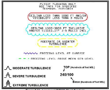
- Low level Significant Weather (SIGWX) charts
- From 24.000 ft MSL and below
- Ceilings
- Turbulence
- Freezing level
- Clouds top and bases
- Weather warning products
- WA - airmet - dangerous for small aircrafts
- HIWAS - hazardous inflight weather advisory service
- Sigmet - all aircrafts, greater than airmet
- Convective sigmet - Thunderstorms
- Severe wx outlook chart (AWW)
- Severe wx watch bulletin
- Center wx advisory
- Airmet (WA)
- Airman’s meteorological information
- Issued when necessary valid for 6 hours
- Weather advisory for low level or limited capabilities aircraft:
- Potentially hazard
- Conditions must be widespread
- Types
- Sierra – mountain obscuration / IFR
- Tango – moderate turbulence, surface winds of 30 knts or more
- Zulu – moderate icing or freezing levels
- HIWAS
- Sent over selected VORs (identified by H)
- Summarized AWW, AIRMETs, SIGMETs, convective SIGMETs, center weather advisories (CWAs), urgent pilot reports and radar reports
- Sigmet (WS)
- Significant meteorological information greater than AIRMET
- Issued when necessary valid for 4 hours
- Weather advisory for all aircraft:
- Severe or greater turbulence
- Severe or greater icing
- IFR conditions due to dust, sand, volcanic ash
- Convective sigmet
- Significant meteorological information
- Issued when necessary valid for up to 2 hours
- Weather advisory for all aircraft:
- Thunderstorms (>3000 square miles)
- Line of thunderstorms (>60 nm)
- Severe or embedded thunderstorms (>30 min)
- Severe weather outlook chart (AWW)
- Message issued in order to alert pilots
- Unscheduled and issued as required
- Access through preflight (FSS)
- Levels of possible thunderstorms activity
- Center wx advisory
- Unscheduled weather advisory issued by the ARTCC to alert pilots of existing or anticipated adverse weather conditions within the next 2 hours

No comments:
Post a Comment