Safety of flight
- Collision avoidance and visual scanning
- 70% of your time should be spent scanning outside
- Aircrafts
- Weather
- Terrain
- FAA suggests pilots to scan 10º segments for at least 1 second
- Use the horizon to scan for aircrafts to determine their attitude
- Aircraft above horizon = higher
- Aircraft on horizon = same alt
- Aircraft below horizon = lower
- If there is no relative movement, the aircraft is on the same course
- Airport operations
- Any operations in the vicinity of an airport
- Exercise extreme caution, continue scans
- Right of way - FAR 91.113
- Same aircraft head on → both turn to the right
- Same aircraft perpendicular → aircraft to the left turns to the right
- Aircraft in distress → right of way over all
- Clearing turns
- Clearing left and right before taxing/ turning
- Before a maneuver turn to clear for other aircrafts
- S turns or 180º turns
- Radio call
- Location ( west practice traffic)
- Call sign
- Position
- Altitude
- Where we are going
- Location (west practice traffic)
- Minimum safe altitude
- Altitude you must maintain during flight
- Must allow an emergency landing, following an engine failure, without hazard to person or property
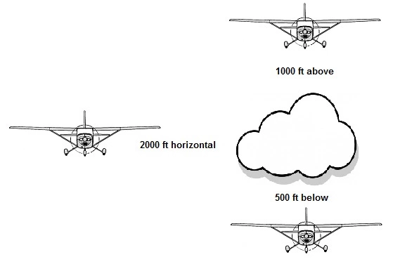
- Over congested area
- 1000 feet over any obstacle with a horizontal radius of 2000 feet of your aircraft
- Over uncongested area
- 500 feet above the surface
- Sparsely populated or over open water areas
- Cannot fly within 500 feet of person, property, vehicle, structure, etc..
- Taxiing in wind
- Strong winds passing over and around the airplane makes it possible for it to roll
- Use the ailerons and elevator to counteract the wind and help you maintain control

- Positive exchange of controls
- Three way exchange
- “You have controls”
- “I have controls”
- “You have controls”
- Controlled and uncontrolled
- Controlled airports
- Have an operating control tower
- Aircrafts must follow instructions issued by ATC
- Two way radio required to operate in controlled airport environment
- Uncontrolled airports
- Control of VFR traffic is not exercised
- Two way radio not required, but advised to be able to transmit intentions to other pilots
- You determine the active runway, and how to enter and exit
- Runway layout
- Main runway aligned with the prevailing wind
- Other runways aligned with the other common wind directions
- Runway numbers correspond to magnetic north reference
- Magnetic direction is rounded off to nearest 10º with the last zero omitted
- Two or more parallel runways will be labeled “L” for left, “R” for right , and “C” for center
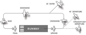
- Traffic pattern
- Established to ensure that air traffic flows into and out of an airport in an orderly manner
- Standard are left traffic pattern turns, unless right turns are indicated by visual markings
- Should be flown at 1000 feet AGL
- Airport visual aids
- Runway markings
- Runway numbers
- Magnetic heading
- Last digit excluded
- Rounded to nearest 10º
- Based on most common wind condition
- Threshold line
- Where the runway starts
- Threshold marker
- Number of parallel lines that represent runway width (AIM 2-3-3)
- Displaced threshold
- Takeoffs and taxi is ok, NO LANDINGS
- Touchdown zone marker
- 500 feet from the threshold line
- 1,2 or 3 parallel lines
- Aiming zone marker
- Two white rectangular stripes 1000 feet from the threshold
- Blast Pad/over run area
- Used for jet wash
- No takeoff,taxi,or landing
- Emergency use only

- Taxiway markings
- Holdshort line
- Not allowed to cross solid lines without clearance
- Cross dashed line after landing, then stop if not instructed otherwise
- ILS holdshort
- Prevents interference with ILS signal
- Non-movement area line
- Marks the border between movement area and non movement area
- Movement area is the part of the airport where aircraft's takeoff/land
- Airport signs
- Mandatory instruction signs
- Red background with white letters
- Runway entrance
- Critical area
- Area prohibited for aircraft's
- Locations signs
- Black background with yellow text
- Identifies your location
- Direction signs
- Yellow background with black text
- Always contains arrows
- Direction to taxiway or runway
- Destination signs
- Yellow background with black text
- Always contains arrows
- Directions to location
- Terminal, cargo, fuel, parking
- Runway distance signs
- Black background with white numbers
- Posted along the runway
- Remaining runway distance in thousands of feet

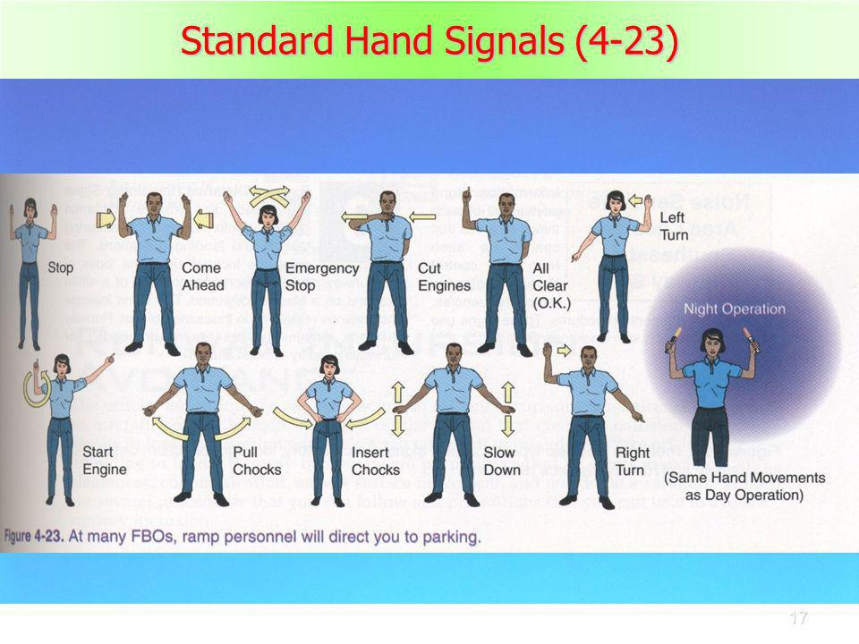
- Ramp area and hand signals
- Where aircraft's are parked and tied down
- Runway incursion avoidance
- When an aircraft, vehicle, person, or equipment is on the runway without clearance
- No part of the aircraft can cross the solid line of the holdshort line
- Do not enter or cross the runway unless cleared
- If in unfamiliar airport
- Hard to see where you are going
- Ask for progressive taxi
- Land and holdshort operations - LAHSO
- The PIC has to determine if this is possible or not
- PIC is expected to decline his operation if it will compromise safety
- If you accept a LAHSO you should land and exit the runway at the first convenient taxiway
- If go around necessary, maintain separation and notify ATC
- Approach lighting system
- See TPP’s for different types
- Dot means running rabbit
- Black means pilot controlled lighting
- Runway lighting
- Visual glide slope indicators
- PAPI/VASI
- Threshold lights
- Bidirectional
- Green at beginning of runway, Red at end of runway
- Runway edge lights
- High, medium, low intensity lights → HIRL, MIRL, LIRL
- You can usually change intensity by pilot controlled lighting
- Runway centerline lights
- Only instrument precision approaches
- White in the beginning, alternating white/red last 3000 feet, red last 1000 feet
- Runway end identifier lights - REIL
- Provides rapid and positive identification of the approach end
- Airport beacon and obstruction lights
- Operational from dusk til dawn and during IFR
- Civil airport → white/green
- Military airport → white white green
- Heliport → white green yellow
- Seaplane → white yellow

- Chart grid
- Latitude
- Imaginary lines parallel to the equator
- Numbered from 0 to 90 degrees.
- Equator is the 0 degree line, and north-pole is the 90 degree.
- Longitude
- Imaginary lines than run from North pole to South pole.
- Total of 360 degrees around the world
- Prime meridian 0 Degree line = Greenwich, England
- Projections
- Transferring sections of the earth's surface onto a flat char
- Vfr charts
- Top of chart is true north
- Type of vfr charts
- Sectional - updated every 6 months
- Vfr terminal area chart (TAC) -
- Similar to sectional
- Mostly for class B airspace
- More detailed
- Updated every 6 months
- World aeronautical chart
- Similar to sectional
- Covers large area
- Less detailed
- High fast aircrafts
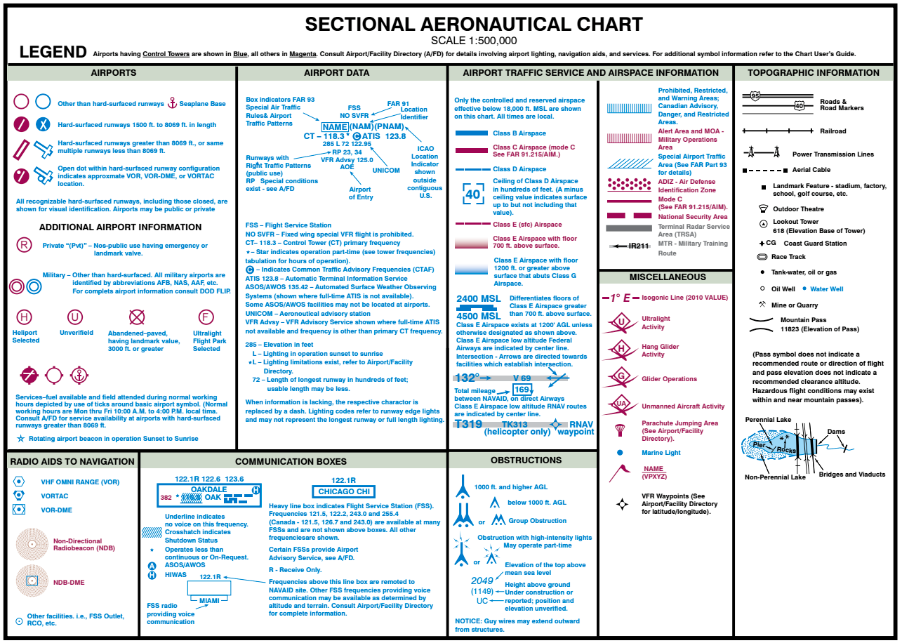
- Chart symbology
- The legend is your tool for deciphering symbols and decoding aeronautical chart info
- The legend is divided into seven categories
- Symbology for airports
- Airport data
- Radio aids to navigation and communication boxes
- Airport traffic service and airspace info
- Obstructions
- Topographic info
- Miscellaneous data
Airspaces
- Classifications
- Controlled and uncontrolled
- Uncontrolled airspace: Class G
- ATC has no authority or responsibility to control air traffic
- Not required to communicate with ATC when operating in class G unless a temporary control tower has been established
- Controlled airspace: Class E, D, C, B, A
- May be subjected to ATC
- ATC primary function is traffic separation
- ATC primary tool is radar, because of this, the FAR requires you to use a transponder in controlled airspaces
- Class echo
- No communication requirements
- No equipment required
- Cannot fly if weather is below VFR minimums, unless you are flying IFR
- Can start at
- Surface agl, end at 17,999 agl
- 700 agl, end at 17,999 agl
- 1200 agl, end at 17,999 agl
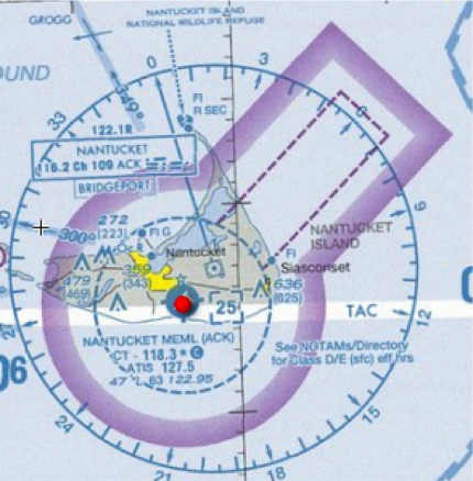
- Class delta
- Airport that has a control tower, but does not provide radar services
- Must establish two-way-radio communication with the tower prior to entering the airspace
- Starts at surface, ends at 2,500 agl
- Usually a 4nm radius
- Equipment
- 2 way radio
- No specific certificate
- When tower is closed, reverts to class E or G
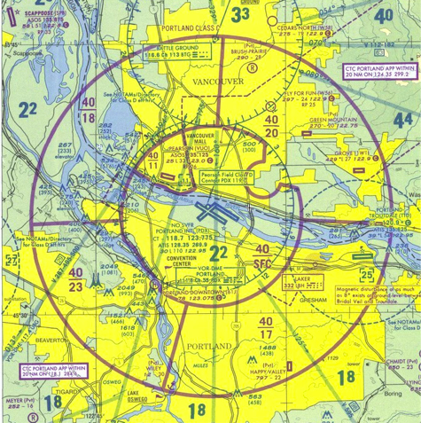
- Class charlie
- ATC provides radar services up to 20 NM from the primary airport
- Inside charlie radar services are mandatory
- Starts at the surface, ends at at 4,000 agl (charted in msl)
- Has different altitudes
- 10nm and 5nm radius
- No specific certificate
- Equipment required
- 2 way radio communication
- Mode C transponder in and above charlie up to 10,000 feet
- Class bravo
- Starts at surface, ends at 10,000 msl
- Has different altitudes (shelves)
- Rules
- Private certificate
- Student certificate with proper CFI endorsement (61.95)
- Clearance to enter
- Equip. Required
- Transponder mode C (needed inside mode C veil, inside B, and over 10,000 MSL)
- Class alpha
- Starts at 18,000 msl and ends at FL600 msl
- Is not show on sectional chart
- Equipment required
- 2 way radio
- nav. Equipment
- Transponder mode C
- Rules
- Private license
- Instrument rating
- Clearance to enter


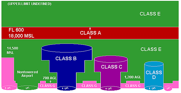
- Weather requirements
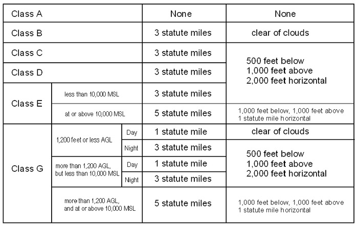
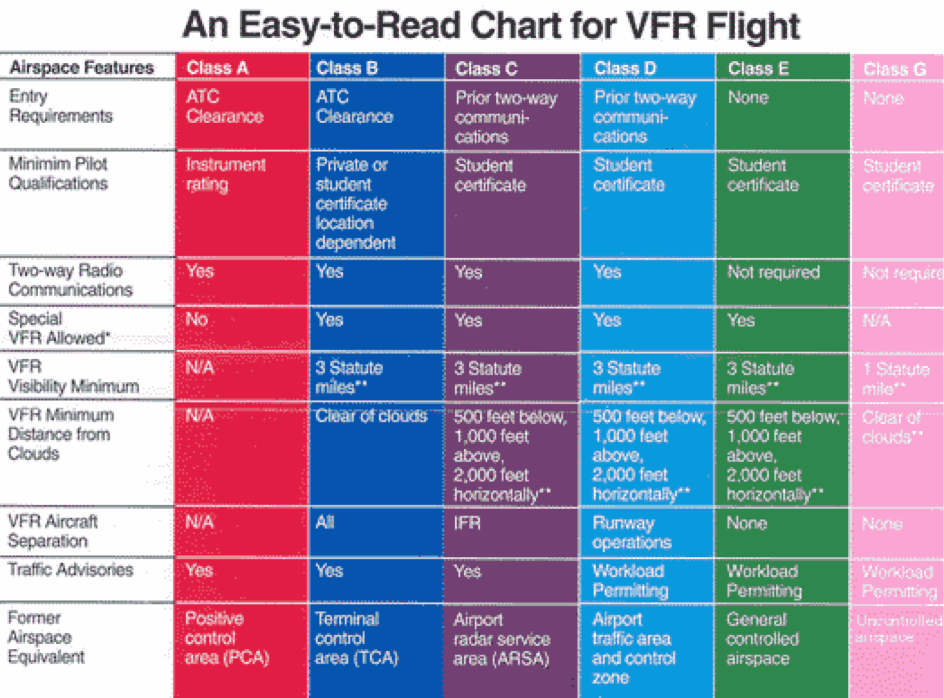
- Special VFR FAR 91.157
- When weather is below VFR minimum and there is no conflicting IFR traffic, special VFR can be requested from ATC
- Allows you to enter, leave, or operate within most class C and E airspaces
- Visibility must be at least 1 sm and clear of clouds
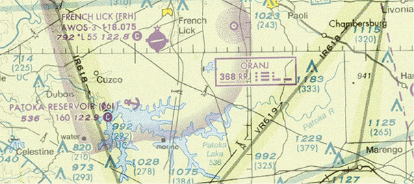
- Special use airspace/Other airspace areas
- Special use airspaces - MC WRAPN
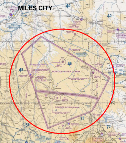
- Military area
- Area where military training and other military maneuvers is being conducted
- Usually have a specific floor and ceiling
- VFR aircrafts are not prevented from entering active MOA’s
- Controlled firing area
- Activities are suspended immediately when an aircraft is in the area
- Not on the chart
- Warning area
- 3 nm outward from the coast of the US
- Contains activities that may be hazardous to nonparticipating aircraft's
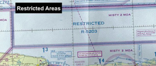
- Restricted area
- Often have invisible hazards to aircraft's
- Permission to fly through must be granted by controlling agency


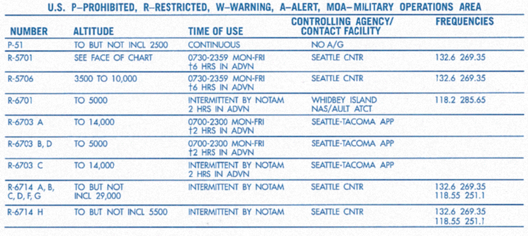
- Alert area
- High volume of aircraft's
- Be alert

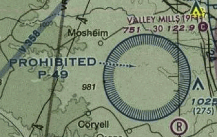
- Prohibited area
- Established for security or other reasons associated with national welfare
- Flight for aircraft is prohibited (must obtain permission to fly through)
- NSA area
- Locations where increased security for ground facilities is required
- Pilots are requested to avoid the area
- NSA can make area prohibited
- Other airspace's
- Military training routes
- IFR/VFR (IR/VR)
- MTR’s with no segment above 1500 agl will be identified by 4 numbers
- MTR’s with one or more segments above 1500 agl will have 3 numbers
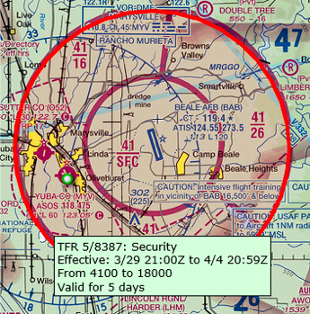
- TFR’s - FAR 91.137
- A NOTAM will be issued designating an area within which TFR’s apply and specify the hazard of conditions requiring their imposition
- TFRs are established to protect persons and property in the air or on the surface, aircrafts are prohibited to fly through
- Emergency air traffic rules
- Established by the FAA immediately after determining that, without such action, the air traffic control system could not operate at the required level of safety and efficiency
- Notam will be issued


- Air defense identification zone (ADIZ)
- All aircrafts entering the U.S airspace from outside the country must provide identification prior to entry
- ADIZ are established to facilitate this identification
.
No comments:
Post a Comment